
Extension of the operational “Space Emergency System” in the HU-SK-RO-UA cross-border region
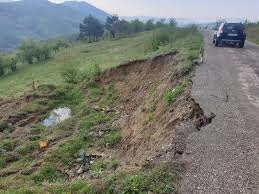
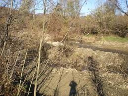
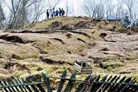
In recent decades, in the Carpathian Euroregion, ecological disasters have become more frequent. Territories with observed deformations of the earth’s surface (recent geotectonic movements, landslides) are found in relatively densely populated areas. Any movement of the surface due to the reported dangerous processes can destroy different types of structures on the earth’s surface, endanger human lives and property and have a serious impact on the success of environmental protection activities. Due to climate change, HU-SK-RO-UA border areas are increasingly at risk from sudden and severe weather events (heavy rainfall, snowfall, landslides and mudslides), causing severe floods that threaten the population and the economy.Thus, a comprehensive assessment of threats and risks in the Carpathian region is needed. Detailed monitoring of land surface deformation in the HU-SK-RO-UA region is not yet resolved. Therefore, an overall analysis of recent surface deformations is proposed in order to obtain detailed knowledge of the current situation, as well as to be able to identify the focus areas of additional local studies to assess the risks associated with surface deformation (i.e. landslides, landelevation, subsidence). We aim to use the most modern satellite technologies (radar interferometry, GNSS, precision leveling, terrestrial and aerial photogrammetry, etc.) to achieve this goal.